Latitude: 53.57477° N, Longitude: -109.7937° W
Central - 22 km W and S of Frenchman Butte, off Grid 797.
Central - 22 km W and S of Frenchman Butte, off Grid 797.
Add to Suitcase
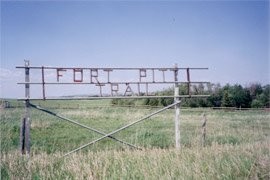
A National Historic Site of Canada, Fort Pitt features the archaeological remains of two different posts, interpretive panels explaining the history of the site, the Northwest Resistance and the signing of Treaty Six as well as a picnic area, washrooms and canoe access to the river.
Fort Pitt was built in 1829 by the Hudson's Bay Company (HBC) to act as a halfway point between Fort Carlton and Fort Edmonton. Located on the northern bank of the North Saskatchewan River, the fort was an important fur trade post and operated for approximately 70 years. In 1876, the site was used as one of the locations for signing Treaty Six and then in 1885 it was a significant site in the Northwest Resistance.
Open May long weekend to Sep 15.
A National Historic Site of Canada, Fort Pitt features the archaeological remains of two different posts, interpretive panels explaining the history of the site, the Northwest Resistance and the signing of Treaty Six as well as a picnic area, washrooms and canoe access to the river.
Fort Pitt was built in 1829 by the Hudson's Bay Company (HBC) to act as a halfway point between Fort Carlton and Fort Edmonton. Located on the northern bank of the North Saskatchewan River, the fort was an important fur trade post and operated for approximately 70 years. In 1876, the site was used as one of the locations for signing Treaty Six and then in 1885 it was a significant site in the Northwest Resistance.
Location Info
22 km W and S of Frenchman Butte, off Grid 797.lat. 53.57477° N, long. -109.7937° W


