North - La Ronge - Hwy 2
Add to Suitcase
Latitude: 55.11412° N,
Longitude: -105.2947° W
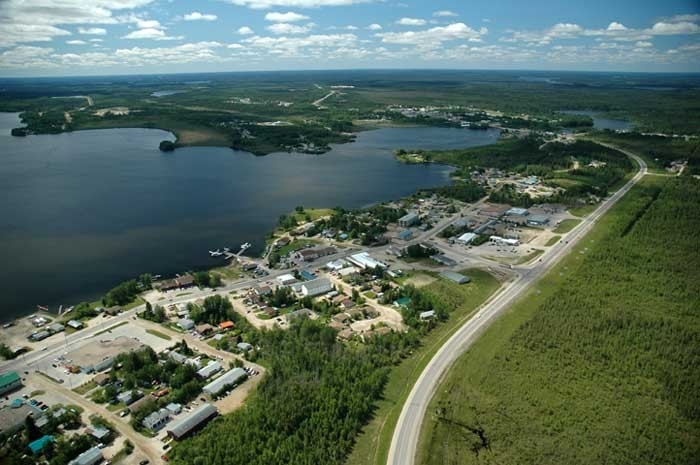
Situated along the shoreline of Lac La Ronge, this full-service northern town is the base for exploring Saskatchewan's far north. The bustling La Ronge Airport is home to several charter air companies and offers scheduled air service to the far north and to the south. From sandy beaches and Precambrian outcrops, to expansive bays and whitewater rivers, the scenery of Lac La Ronge and the Churchill River System is amazing. Year-round recreational opportunities abound - enjoy world-class canoeing and fishing, and some of the best cross-country ski trails in North America.
TRAVELLER INFO
Woodlands & Waterways Regional Information Centre, 11 La Ronge Rd, Hwy 2 S, Mon to Fri 10 a.m. - 4 p.m., Thu 10 a.m. - 8 p.m., Sat and Sun 12 noon - 4 p.m. Closed Sun during winter months. Canoe route guides and maps, canoe trip registration and gift shop on site.
306-425-3056
306-280-7084
Email: wwrvc2.0@gmail.com
North - La Ronge - Hwy 2
Situated along the shoreline of Lac La Ronge, this full-service northern town is the base for exploring Saskatchewan's far north. The bustling La Ronge Airport is home to several charter air companies and offers scheduled air service to the far north and to the south. From sandy beaches and Precambrian outcrops, to expansive bays and whitewater rivers, the scenery of Lac La Ronge and the Churchill River System is amazing. Year-round recreational opportunities abound - enjoy world-class canoeing and fishing, and some of the best cross-country ski trails in North America.
La Ronge
Latitude: 55.11412° N,
Longitude: -105.2947° W
TRAVELLER INFO
Woodlands & Waterways Regional Information Centre, 11 La Ronge Rd, Hwy 2 S, Mon to Fri 10 a.m. - 4 p.m., Thu 10 a.m. - 8 p.m., Sat and Sun 12 noon - 4 p.m. Closed Sun during winter months. Canoe route guides and maps, canoe trip registration and gift shop on site.
306-425-3056
306-280-7084
Email: wwrvc2.0@gmail.com